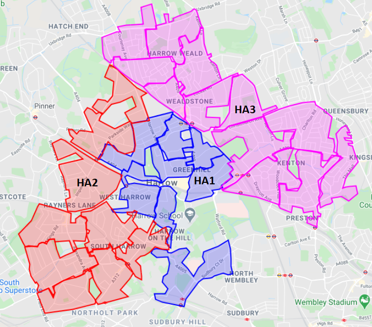
Leaflet distribution Harrow (HA1, HA2, HA3) is one of our most frequented area for distributions. We have accumulated great amount of knowledge distributing our clients’ leaflets in Harrow (HA1, HA2, HA3) postcodes in the past 7 years.
Harrow’s name is originated from the Old English name of “hearg”, which means “heathen temple”. The temple most likely it was situated on the top of the hill of Harrow, where St. Mary’s Church stands nowadays.
Top Landmarks:
Harrow has 2 large shopping centres, St Anns and St George’s situated close to Harrow-on-the-hill tube station. They contain many chain stores typical on British high streets.
HarroWall Climbing Centre is the UK’s largest indoor bouldering centre suitable for all age groups for climbing activities.
Harrow is made up of 9 wards: Harrow on the Hill, Harrow Weald, Headstone, North Harrow, Kenton, Rayners Lane, South Harrow, Wealdstone and West Harrow. The Borough of Harrow had a population of 250149 people in 2011.
Ethnicities:
30.8% White British, 8.2% Other White, 42.2% Asian (26.3% Indian), and 8.1% Black. (ONS, 2011 Census).
Leaflet distribution Harrow HA1
See below the list of postcodes within the HA1 area covering the areas of Harrow, Harrow on the Hill, North Harrow, Northwick Park, Sudbury (north), Sudbury Hill. HA1 postcode contains approximately 15,519 households with a population of about 38,479 (2011 census). In HA1 (especially in HA1 1, HA1 2), there have been 100s of new flats built, which we have added to the 2011 Census data.
|
Postcodes |
Households |
Demographic (Mainly) |
|
HA1 1 |
3215 |
Medium- to high-income households |
|
HA1 2 |
3327 |
Medium- to high-income households |
|
HA1 3 |
3863 |
Mainly high-income households |
|
HA1 4 |
5114 |
Medium- to high-income households |
|
HA1 |
15519 |
|
Leaflet distribution HA2
This is a list of postcodes in the HA2 area covering the areas of North Harrow, South Harrow, West Harrow, Rayners Lane (south).
HA2 postcode has about 20,940 households with a population of about 55,524 (2011 census).
|
Postcodes |
Households |
Demographics (Mainly) |
|
HA2 0 |
4846 |
Medium- to high-income |
|
HA2 6 |
2987 |
Mainly high-income |
|
HA2 7 |
3017 |
Medium- to high-income |
|
HA2 8 |
4794 |
Low- to medium-income |
|
HA2 9 |
5296 |
Medium- to high-income |
|
HA2 |
20940 |
|
Leaflet distribution HA3
HA3 postcode area covers the following areas of Harrow Weald, Kenton, Wealdstone, Queensbury, Belmont (west and south).
HA3 postcode has about 24,855 households with a population of about 70,816 (2011 census).
|
Postcodes |
Households |
Demographics (Mainly) |
|
HA3 0 |
3742 |
High-income |
|
HA3 5 |
3599 |
Low- to medium-income |
|
HA3 6 |
3655 |
High-income |
|
HA3 7 |
4532 |
Medium- to high-income |
|
HA3 8 |
4271 |
Medium- to high-income |
|
HA3 9 |
5056 |
Medium- to high-income |
|
HA3 |
24855 |
|
In the previous years, our leaflet distributors gained a vast experience and a thorough area knowledge in distributing our customers’ flyers in Harrow.
GATE Leaflet Distribution is one of the most (maybe the most) knowledgeable leaflet distribution Harrow (HA1, HA2, HA3) company to deliver your leaflets. You can trust that GATE will deliver all your leaflets in Harrow postcodes to the highest standard possible. We have the invaluable local knowledge, what we have built over of continuous distribution in Harrow.
If you have any enquires about leaflet distribution HA1 HA2 HA3 Harrow, then please contact us today! You can book your next campaign with GATE. Drop us an email at [email protected] or call us on 02089026388.
Let us be the GATE to your customers!
Recent Comments